
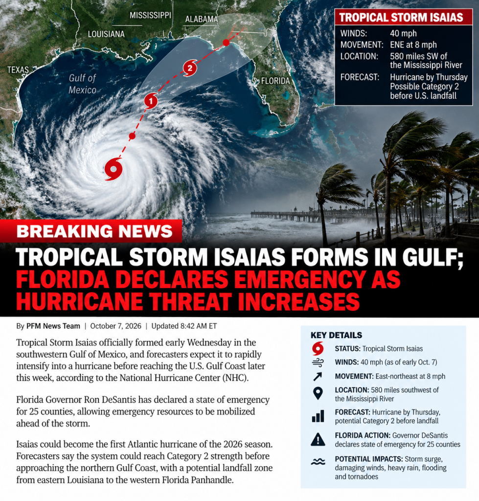
Tropical Storm Isaias Forms in Gulf; Florida Declares Emergency as Hurricane Threat Grows
MIAMI, Fla. — October 7, 2026 — Tropical Storm Isaias has formed in the Gulf of Mexico and is forecast to rapidly strengthen into the first Atlantic hurricane of the 2026 season before approaching the northern U.S. Gulf Coast later this week.
Florida Governor Ron DeSantis has already declared a state of emergency for 25 counties as state emergency officials begin positioning supplies and equipment ahead of the storm.
The National Hurricane Center upgraded Tropical Depression Nine to Tropical Storm Isaias early Wednesday morning after maximum sustained winds increased to 40 mph.
As of the early Wednesday advisory, Isaias was approximately 580 miles southwest of the mouth of the Mississippi River and moving east-northeast at about 8 mph.
Forecasters expect the storm to turn northeast and then north Thursday and Friday as it moves across the warm waters of the Gulf.
Isaias Could Rapidly Strengthen
The National Hurricane Center is forecasting rapid strengthening during the next couple of days.
The latest NHC intensity forecast has Isaias becoming a hurricane by Thursday and potentially reaching maximum sustained winds of approximately 110 mph Friday morning, which would make it a strong Category 2 hurricane.
Forecasters warned that Isaias could be a “significant hurricane” as it approaches the northern Gulf Coast.
The storm’s strength near landfall remains uncertain, however. Increasing wind shear could weaken Isaias somewhat immediately before it reaches land.
Even if weakening occurs, the National Hurricane Center warns the storm’s wind field could expand as it approaches the coast, meaning dangerous conditions could extend well beyond the exact center of circulation.
Hurricane Watch Issued
A hurricane watch has now been issued for portions of the northern Gulf Coast, including an area extending from Bay St. Louis, Mississippi, to Indian Pass in the Florida Panhandle.
A hurricane watch means hurricane conditions are possible within the designated area, generally within 48 hours.
The storm is currently forecast to approach the northern Gulf Coast Friday before potentially making landfall late Friday or early Saturday.
Residents from Louisiana through Mississippi, Alabama and the Florida Panhandle are being urged to closely monitor updated forecasts.
The exact landfall location could still shift.
Florida Declares State of Emergency
Governor DeSantis signed Executive Order 26-202 declaring a state of emergency across 25 Florida counties.
The declaration covers much of the Florida Panhandle and Big Bend.
Florida’s State Emergency Response Team is mobilizing resources including generators, fuel, flood barriers, bottled water, shelf-stable meals, tarps, sandbags and temporary flood-control barriers.
Emergency resources are being strategically staged around Tallahassee and Santa Rosa County so they can be rapidly deployed if necessary.
State officials are urging residents in potentially affected areas to review hurricane plans and make sure emergency supply kits are stocked.
25 Florida Counties Under Emergency Declaration
The emergency declaration covers:
Baker, Bay, Calhoun, Columbia, Dixie, Escambia, Franklin, Gadsden, Gilchrist, Gulf, Hamilton, Holmes, Jackson, Jefferson, Lafayette, Leon, Liberty, Madison, Okaloosa, Santa Rosa, Suwannee, Taylor, Walton, Wakulla and Washington counties.
Heavy Rain and Flash Flooding Possible
Wind will not be the only concern.
The National Hurricane Center forecasts 3 to 6 inches of rainfall across portions of the northern Gulf Coast, with localized totals potentially reaching 10 inches.
Heavy rainfall could produce flash flooding, urban flooding and isolated river flooding.
The storm’s moisture is also expected to spread well inland.
Parts of the Southeast, Tennessee Valley and Carolinas could receive 1 to 3 inches of rain, with isolated totals approaching 5 inches.
Storm Surge and Dangerous Surf Threat
Forecasters are also warning about the increasing risk of dangerous storm surge along portions of the northern Gulf Coast.
Large swells generated by Isaias are expected to spread northward across the Gulf later this week.
Those conditions could produce dangerous surf and life-threatening rip currents even in areas away from the eventual landfall point.
Storm-surge watches could be expanded as the forecast becomes clearer.
Could Become Latest First Hurricane in More Than a Century
The 2026 Atlantic hurricane season has been unusually quiet.
If Isaias becomes a hurricane Thursday as forecast, it could tie or approach a remarkable historical record.
According to the National Weather Service, the latest first Atlantic hurricane of a season occurred in 1905, when the year’s first hurricane formed on October 8.
That means Isaias could become the latest-forming first hurricane of an Atlantic season in approximately 121 years.
Residents Urged to Prepare Now
Officials emphasize that people should not focus solely on the center line of the forecast track.
Hurricane-force winds, storm surge, heavy rainfall and tornadoes can occur well away from a hurricane’s center.
Residents from Louisiana through the Florida Panhandle should monitor National Hurricane Center forecasts and instructions from local emergency-management officials as Isaias strengthens.
The next 24 to 48 hours will be critical in determining how powerful the storm becomes and exactly where it will approach the Gulf Coast.
**Patriots First Media will continue monitoring Tropical Storm Isaias and provide updates as new watches
Article discussion